Colorado wildfires: 5 fires on Western Slope destroy nearly 21,000 acres
Published in News & Features


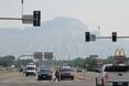
DENVER — Smoke continues to fill the skies of Colorado on Wednesday as firefighters battle five wildfires along the state’s Western Slope.
Four of the fires were sparked last Thursday during an afternoon storm and have continued to grow, together consuming nearly 21,000 acres, according to fire officials.
The fifth fire spread into Colorado from Utah on Tuesday, though its Colorado footprint remains unknown.
A fresh air-quality advisory was issued Wednesday by the Colorado Department of Public Health and Environment for wildfire smoke.
The advisory lasts from 8 a.m. Wednesday to at least 9 a.m. Thursday and covers Chaffee, Delta, Gunnison, Eagle, Garfield, Lake, Mesa, Montrose, Ouray and San Miguel counties.
“Thunderstorms are possible near the fires on Wednesday, and may produce gusty, erratic winds that can send smoke in any direction,” state health officials stated in the advisory.
Turner Gulch fire and Wright Draw fire near Gateway
Mesa County’s Turner Gulch fire, which exploded in size late Monday night and early Tuesday morning, consumed another 5,800 acres Tuesday, according to fire officials.
The wildfire, which had burned just over 1,400 acres Monday afternoon, has now reached 13,984 acres with no containment, according to federal fire maps Wednesday morning.
The Wright Draw fire on the opposite side of Unaweep Canyon is burning on 448 acres, fire officials said.
“All in all, it hasn’t done a whole lot, but I don’t trust it,” Operations Section Chief Rob Powell said of the Wright Draw fire during a Tuesday afternoon briefing. “If it gets to the bottom of the draw, lines up with the slope and gets an updraft, it’s going to want to go.”
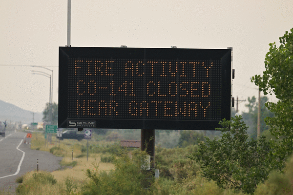
While the Turner Gulch fire has spread miles along Colorado 141 in the past two days, it’s yet to cross the highway, where fire crews are working to protect homes and power and fiber-optic lines.
It’s unlikely the fire will be contained in the next two weeks, Powell said.
Colorado 141 remains closed between 7.40 Road and 16.10 Road at mile marker 124 for the fire, according to state transportation officials.
Land around Colorado 141 from mile marker 120 to mile marker 134 is under mandatory evacuation orders, according to Mesa County sheriff’s officials. The stretch between mile markers 134 and 137 remains under pre-evacuation orders.
Deer Creek fire near Paradox
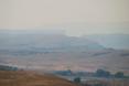
The Deer Creek fire that crept into Colorado from Utah has destroyed more than 14,700 acres between the two states, fire officials said.
As of Wednesday morning, the wildfire was burning on 14,760 acres and was 7% contained. That’s another 1,800-acre jump from Tuesday, when Utah officials first reported the fire had crossed state lines.
Although it’s unknown how many acres the Deer Creek fire has scorched in Colorado, federal fire maps showed it was burning on a section of land more than two miles long and, at its widest, about two miles across.
The burn area is just north of Colorado 90 in Montrose County, near Paradox. It encompasses multiple county roads and parts of both Ice Lake Creek and Lion Creek.
Dry thunderstorms and gusty winds fueled the fire’s overnight growth, fire officials said.
The fire has shut down Rimrocker Trail at Q13 Road and Good Road, U5 Road at the turn for the Buckeye Reservoir and X2 Road, according to Montrose County officials.
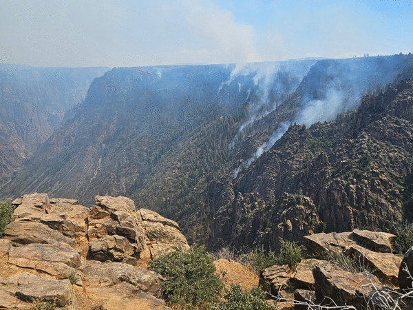
South Rim fire near Montrose
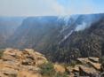
A wildfire that sparked in Black Canyon of the Gunnison National Park is burning on more than 4,000 acres with no containment, including most of the park’s south rim, according to fire officials.
The South Rim fire was last mapped at 4,160 acres in and around the park, Rocky Mountain Area Complex Incident Management Team 3 officials said Wednesday. Fire crews are making good progress on building fire lines and are focused on the western edge of the fire, though extremely steep terrain is making that difficult along the northwest side.
Flames have consumed about 85% of the Black Canyon’s south rim, park Superintendent Stuart West said at a community meeting Tuesday night at Grace Community Church in Montrose.
“It will look very different than when you saw it last time,” he told the crowd.
While the visitor’s center is still standing, the fire destroyed a maintenance building and all of the park’s heavy equipment.
The national park remains closed to the public with no timeline to reopen, and mandatory evacuations are in effect for nearby homes and trails, including the Bostwick Park area. All campground reservations for Black Canyon have been canceled for the rest of 2025 and the park will not be taking any new reservations, West said.
As of Monday morning, two zones — including a section north of U.S. 50 along Colorado 347 and an area between Rawhide Gulch and the Montrose Reservoir — were under pre-evacuation orders, according to a map created by Montrose County officials.
Even after the fire is under control, visitors will not be able to enter the inner canyon because of unstable rock, West said.
“We realize the Black Canyon is a valuable resource to this community and to the country and a return to normal is in everyone’s best interest, but it’s going to take quite some time,” he said.
Black Canyon of the Gunnison generates $35 million in revenue for the city and county of Montrose, emergency manager Scott Hawkins said.
While the nearby Curecanti National Recreation Area is unscathed, about 500 acres of federal land is still at risk, Bureau of Land Management field office manager Jon Kaminsky said Tuesday night. The land includes habitat for the threatened Gunnison sage-grouse, livestock forage and areas of recreation, hunting and fishing.
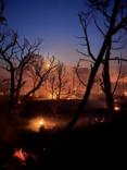
The fire started early Thursday morning when a passing storm caused at least seven lightning strikes in the park, incident meteorologist Scott Stearns said. While more storms moving through the area will bring some cloud cover and cooler temperatures through the weekend, they also bring a high threat of more lightning strikes, which could start new fires, and little chance of substantial rain to aid firefighters.
“This fire is still very active,” fire officials stated on Facebook. “Even with all the good work underway, it takes time — crews need to be confident the fireline will hold, especially in steep and challenging terrain.”
Abundant, extremely dry fuel sources are fueling the fire’s spread day and night and debris rolling down the canyon is igniting areas below, sending flames rushing back up the steep slopes, officials said.
There isn’t an imminent threat of the fire reaching U.S. 50 but it’s not out of the question, Stearns said. Gusty winds up to 20 mph are expected in the fire area during Wednesday afternoon thunderstorms, according to the National Weather Service.
Resources fighting the fire include 420 people, 21 fire engines and multiple helicopters and fixed-wing aircraft along with two scooper planes capable of picking up 1,412 gallons of water in 12 seconds.
Sowbelly fire near Delta
The more than 2,200-acre wildfire burning on the edge of three counties in western Colorado did not grow between Monday and Tuesday, according to the Bureau of Land Management Colorado.
As of Monday morning, the Sowbelly fire had scorched 2,274 acres in the Dominguez Canyon Wilderness Area. That estimate remained the same on Wednesday.
The fire is burning about 12 miles west of Delta, on the edge of Montrose, Delta and Mesa counties.
Firefighters on Tuesday were working to extinguish hotspots on the fire’s northern edge and secure a perimeter around the “creeping and smoldering” fire, BLM Colorado officials said.
Fire officials announced the Sowbelly fire was 13% contained Wednesday morning.
_____
©2025 MediaNews Group, Inc. Visit at denverpost.com. Distributed by Tribune Content Agency, LLC.


Comments