Hurricane Center says Atlantic system could still form despite Florida rains remaining over land
Published in News & Features
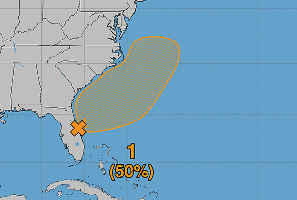
ORLANDO, Fla. — The weather system drenching Florida this week is no longer considered a tropical threat, but there is still a chance low pressure along the same front in the Atlantic could develop into a tropical or subtropical storm this weekend, according to the National Hurricane Center.
As of the NHC’s 1 p.m. EST tropical outlook Friday, several areas of low pressure were located along the front for several hundred miles that extended from Central Florida east into the Atlantic. A portion of that was still dumping flooding rains while moving into North Florida.
The NHC said that portion was likely to remain inland without significant development.
“A second low farther east could acquire subtropical or tropical characteristics while it moves generally northward to north-northeastward, passing near or east of the mid-Atlantic coast through the weekend,” forecasters said.
Whether it develops more or not, the large weather system was expected to bring gusty winds, dangerous surf, rip currents and coastal flooding up the southeast and mid-Atlantic coasts into early next week.
“In addition, heavy rainfall and the threat of flash flooding will continue across portions of the northeast Florida peninsula today, spreading northward over coastal portions of the Carolinas and the mid-Atlantic over the weekend,” forecasters said.
The NHC gives it a 30% chance to develop in the next two days and 40% in the next seven.
The next name on the 2026 Atlantic hurricane season list is Kyle.
The National Weather Service in Melbourne said the track of the low will determine to what degree winds and rainfall will affect the state on Saturday and Sunday.
Rainfall from the system flooded coastal South Florida earlier in the week and continues to dump several inches of rain across Central Florida on Friday. It dropped more than 12 inches in some parts of Brevard County on Thursday flooding roads from the coast and inland including Orange, Seminole and Volusia counties.
One section of the St. Johns River near Cocoa rose to 18.66 feet by Friday morning, more than an inch higher than the previous record from 1953. That section as well as the river in Geneva is already in major flood stage while sections near DeLand and Astor are forecast to reach that level as well while Sanford will be in a moderate flood stage, the NWS stated.
Hurricane season officially runs through the end of the month.
The season has been slow in the Atlantic because of the effects of a strong El Niño weather pattern, which brought a much stronger, tumultuous season for the Pacific.
Only 10 named storms have developed on the Atlantic side, and only one of those became a hurricane. That was Hurricane Isaias, which struck Florida’s Panhandle in October. Isaias did grow into a Category 3 major hurricane in the Gulf before diminishing ahead of landfall striking as a Category 2 hurricane near Destin.
Hurricane season began June 1 and runs through Nov. 30.
The last season forecast from the National Oceanic and Atmospheric Administration came in August, when it forecast 13 named storms, with two to six becoming hurricanes.
An average year would see 14 named storms and seven hurricanes, with three of those growing to Category 3 strength or higher.
----------------
©2026 Orlando Sentinel. Visit at orlandosentinel.com. Distributed by Tribune Content Agency, LLC.






Comments