Hurricane center continues tracking system over Florida that could develop in Gulf
Published in Weather News
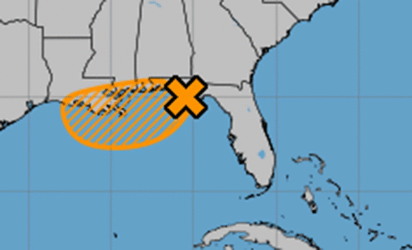
The National Hurricane Center on Wednesday continued to project a medium chance that a system moving over Florida would emerge into the Gulf and develop into the season’s next tropical depression or storm.
As of the NHC’s 2 p.m. Eastern time tropical advisory, the broad area of low pressure had moved along the coast of the Florida Panhandle near Panama City.
“The associated shower and thunderstorm activity is disorganized and located mainly south and southwest of the center,” forecasters said. “This system is forecast to continue moving westward, and could emerge or redevelop over the far northeastern to north-central portion of the Gulf later today or tonight, reaching the coast of Louisiana by Thursday.”
It formed earlier this week in the Atlantic and its tropical moisture has dumped rounds of showers across the peninsula as it tracked west.
“If this system moves far enough offshore, environmental conditions over the Gulf appear generally favorable for additional development, and a tropical depression could still form over the next couple of days before the system moves fully inland by the end of the week,” forecasters said.
The NHC gives the system a 40% chance to develop in the next two to seven days.
If it were the grow into a named storm, it could become Tropical Storm Dexter.
“Regardless of development, heavy rainfall could produce localized flash flooding over portions of Florida through today,” forecasters said. “Heavy rainfall could also cause flash flooding for portions of the north-central Gulf Coast beginning late today and continuing through Friday.”
The National Weather Service in Melbourne said already the eastern portions of Central Florida should begin to dry out, although the normal pattern of rain in the afternoon and evening will return.
“More sunshine and surface heating combined with sufficient low level moisture should allow for rounds showers and storms this afternoon,” forecasters stated. “Southeast winds should generally keep coverage highest across the interior (60-70%) with drier forecast trends focused near and east of I-95.”
The state was previously doused by rains associated with what developed into Tropical Storm Chantal earlier this month. That storm ended up striking the Carolina coast and dumped flooding rains inland.
Before the start of hurricane season, the National Oceanic and Atmospheric Administration had forecast an expected 13 to 19 named storms for the year, of which 6 to 10 would grow into hurricanes. Three to five of those would develop into major hurricanes of Category 3 strength or higher.
Researchers out of Colorado State University this week, though, updated their forecast saying they expect the season to be slightly less busy than what they had predicted earlier this year.
Hurricane season runs June 1 to Nov. 30.
_____
©2025 Orlando Sentinel. Visit orlandosentinel.com. Distributed by Tribune Content Agency, LLC.


Comments